If someone asked where most wildfires occur in Spain, we would probably think of the Mediterranean region, with its warm and dry climate. However, the reality is different: it is the northwest of the peninsula that tops the wildfire statistics. But why is this the case? Let us take a closer look.
The Northwestern Peninsula and the Statistics
To better understand this analysis of wildfires in the northwestern peninsula, it is important to clarify that we are referring to the autonomous communities of Asturias, Cantabria, Galicia, and the provinces of León and Zamora*. This geographic division follows a classification by the Wildfire Defence Area (ADCIF) of the Ministry for the Ecological Transition and the Demographic Challenge (MITECO), which groups territories based on similarities in the number, area, and causes of wildfires. In this way, Spain is divided into four geographic areas: the Mediterranean, the Interior Communities, the Canary Islands, and the Northwest.
The northwestern peninsula, with its distinctive climate and landscape, is one of the wettest regions in the country, featuring rainfall throughout much of the year, moderate temperatures, and high humidity. At first glance, these conditions might seem unfavourable for wildfires. However, the data tell a very different story.
Looking at the period from 2000 to 2021—the most recent span with complete and comparable data—according to the General Statistics on Forest Fires in Spain (EGIF), more than half of all fires (57%) and nearly half of the annual burned area (47.4%) occurred in this region (Figure 1a and b). It is important to note that these figures represent a two-decade average, which simplifies a reality that has changed year by year. Even so, they clearly illustrate how the situation in the northwest differs from that of the rest of the country.
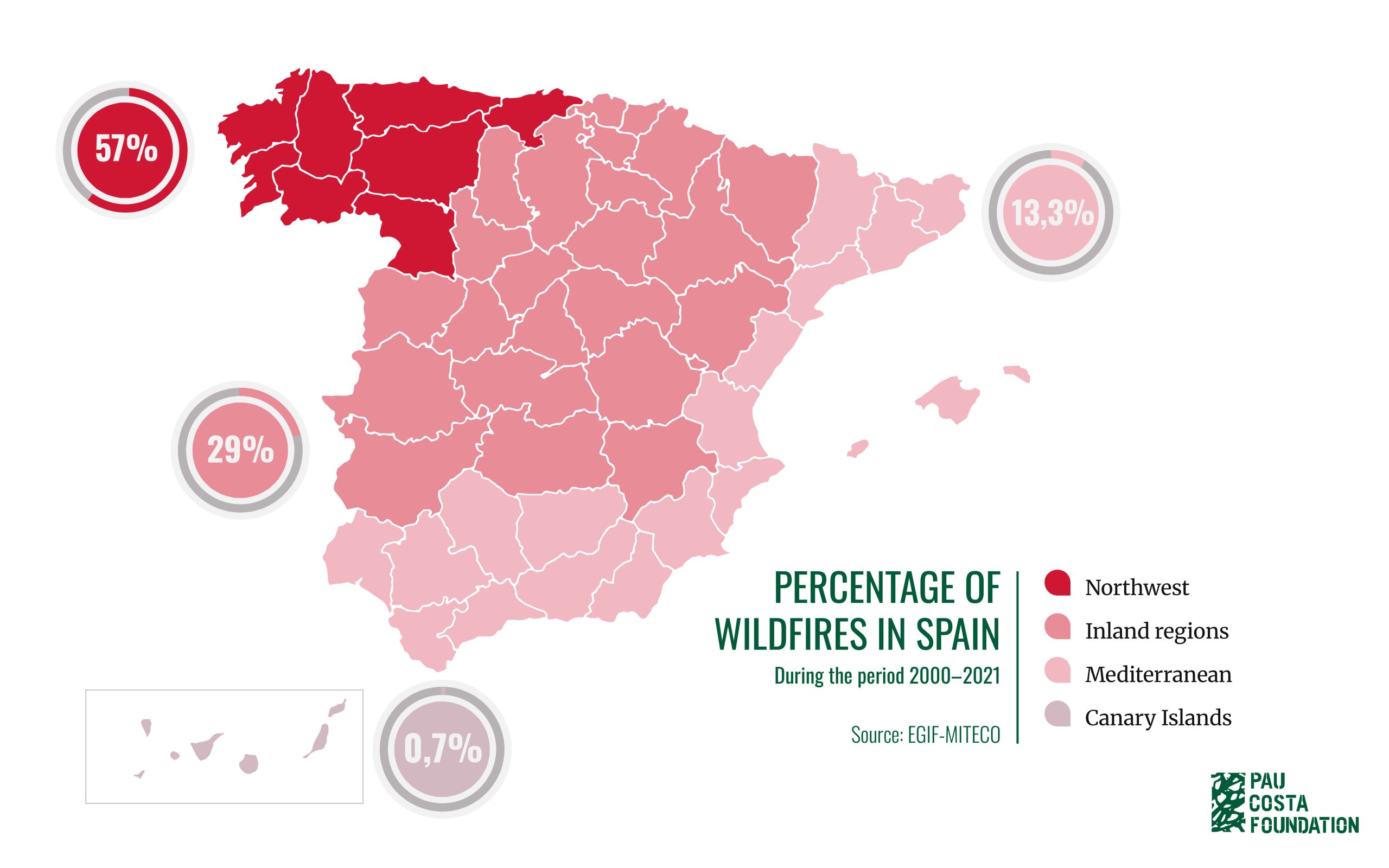
Figure 1. a. Percentage of wildfires from 2000 to 2021 across the four geographic areas (Mediterranean, Interior Communities, Canary Islands, and Northwest)
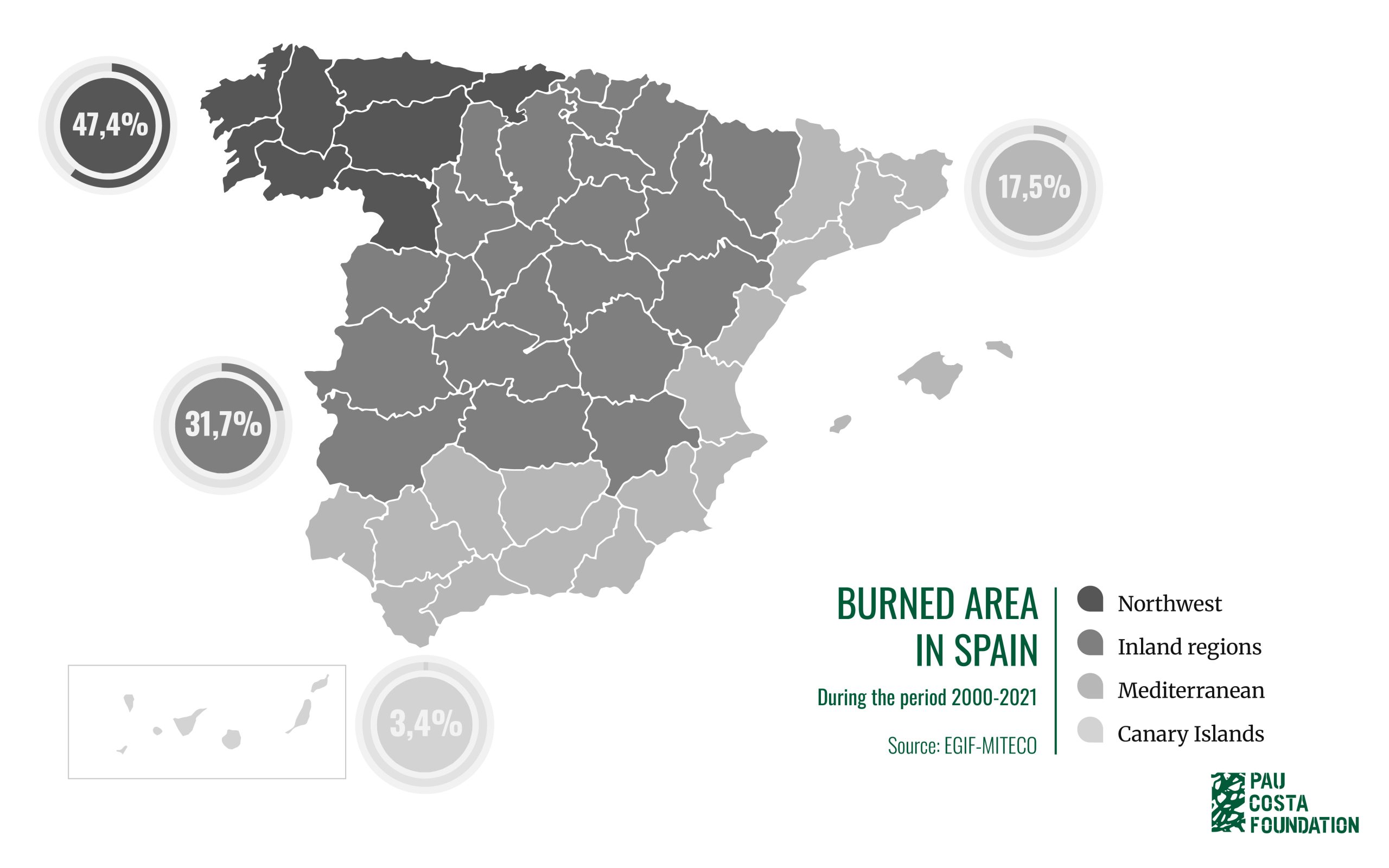
Figure 1.b. Percentage of burned area from 2000 to 2021 across the four geographic areas (Mediterranean, Interior Communities, Canary Islands, and Northwest)
This contrast between such a green and humid environment and the high concentration of wildfires highlights a paradoxical situation: a landscape that seems unlikely to burn is actually where fires occur most frequently. In fact, within the northwest region itself—that is, considering only the fires recorded in this area—the largest proportion occurs in Galicia (63%), followed by Asturias (19.2%) and Cantabria (6.8%) (Figure 2).
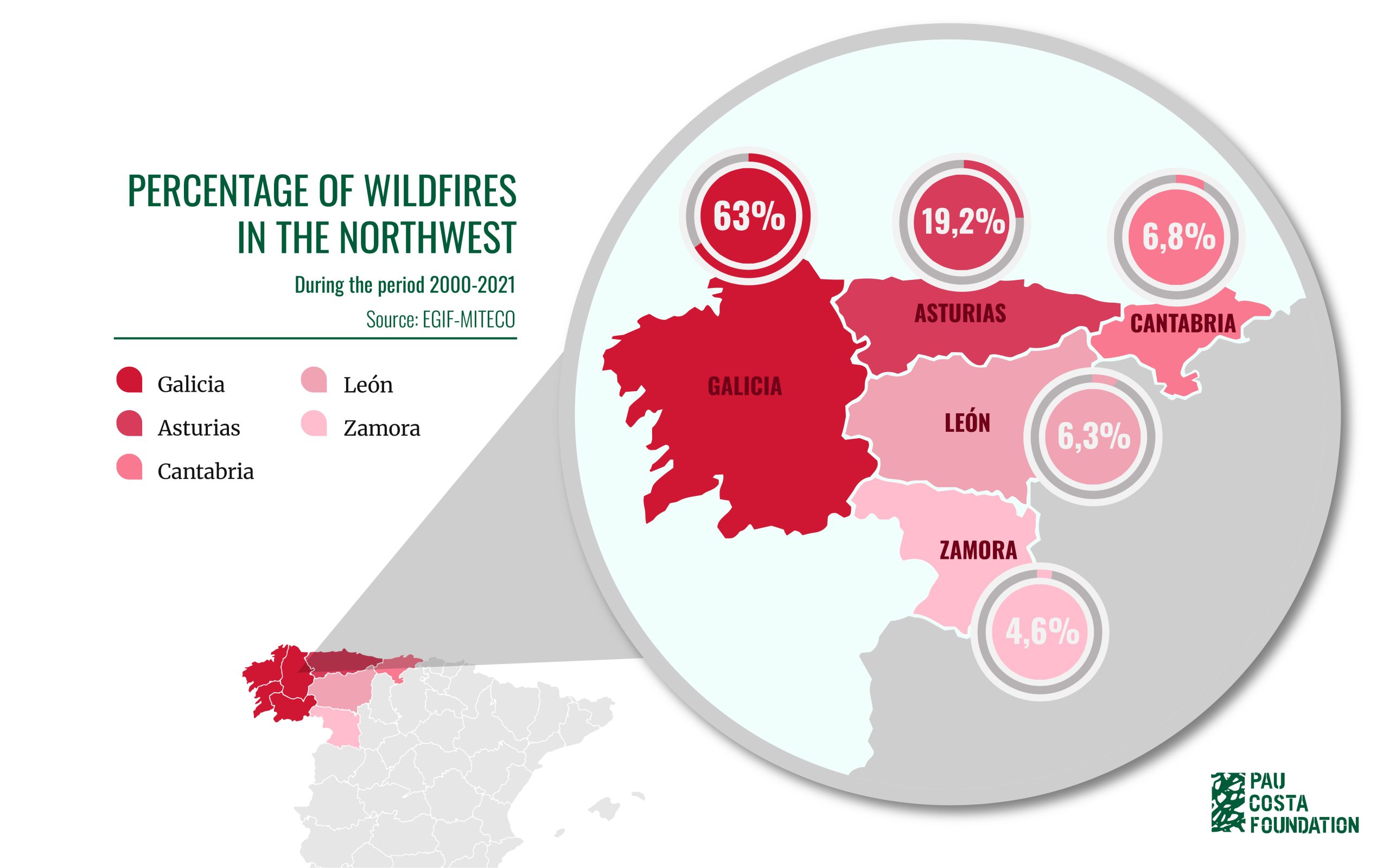
Figure 2. Percentage of wildfires from 2000 to 2021 in the autonomous communities of Galicia, Asturias, and Cantabria, and the provinces of León and Zamora that are part of the Northwest geographic area.
*The Basque Country was part of the Northwest communities until 2018, when it was reclassified as part of the Interior Communities.
When do these wildfires occur?
This is where the pattern becomes even more surprising. While most of Spain sees wildfires mainly in summer, in the northwestern peninsula, many fires occur in winter and early spring (Figure 3).
However, this pattern is not uniform across the northwest. Asturias and Cantabria see most of their fires precisely in winter and early spring, whereas in Galicia and the interior provinces of the northwest (León and Zamora) the annual distribution is different. In Galicia, for example, the province of Ourense experiences more fires in summer, due to its hotter and drier climate compared to the rest of the northwest (Figure 4).
This shows that even within the same geographic area, the fire season varies depending on location and local conditions—cultural, meteorological, and social.
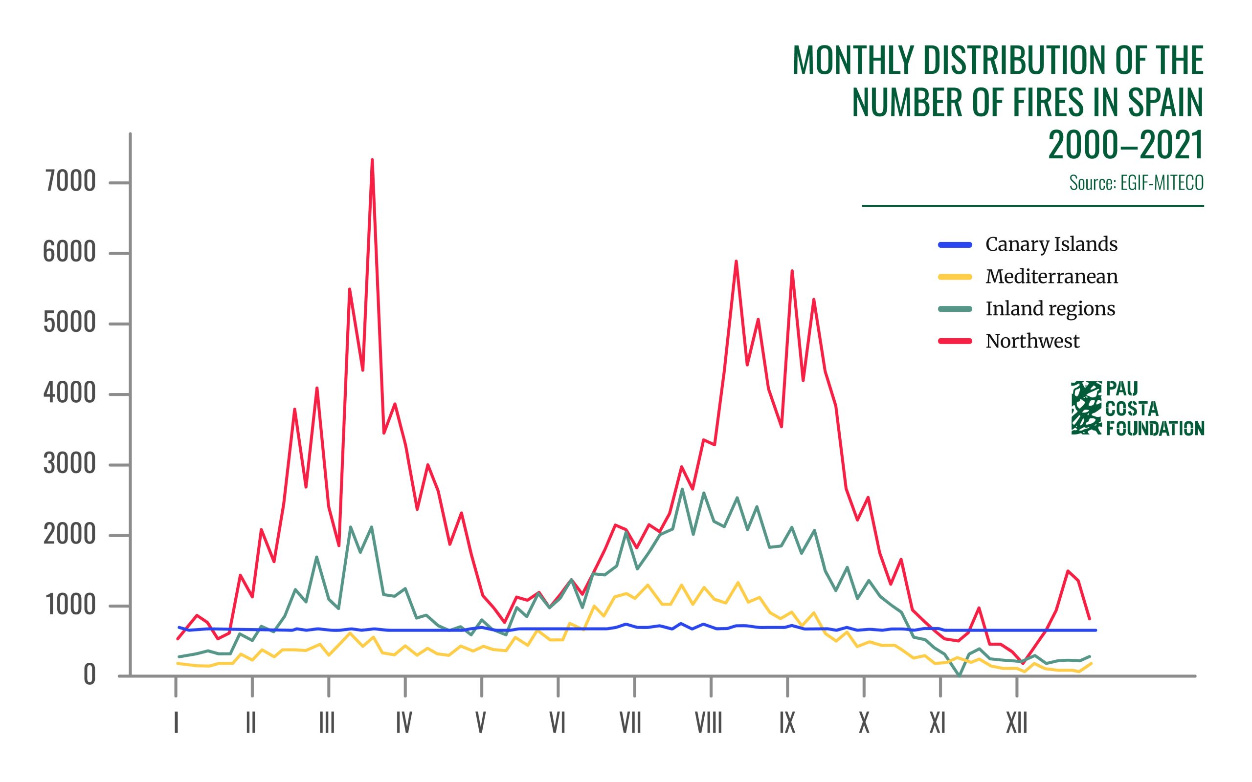
Figure 3. Monthly distribution of the number of wildfires from 2000 to 2021 across the four geographic areas (Mediterranean, Interior Communities, Canary Islands, and Northwest)
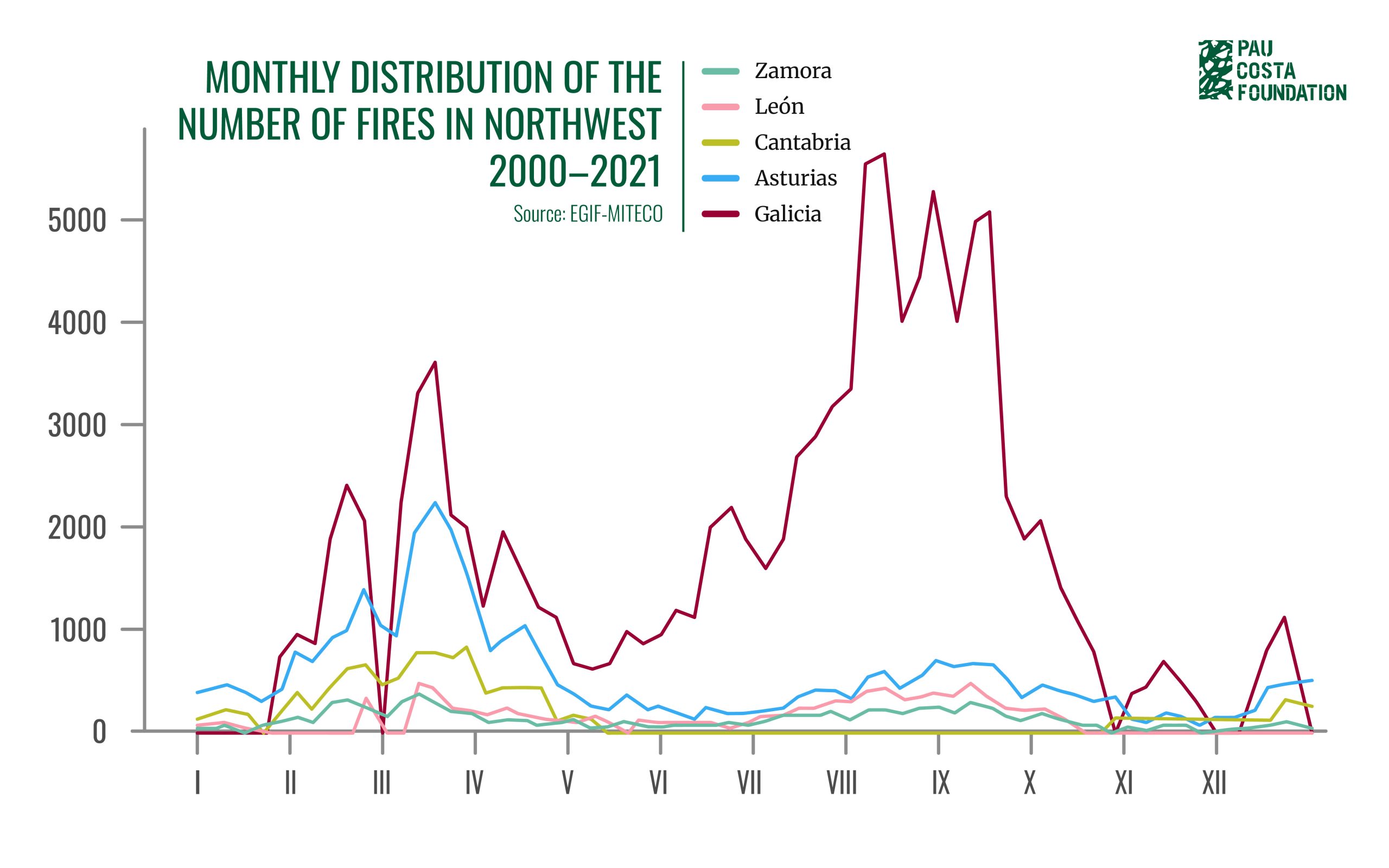
Figure 4. Monthly distribution of the number of wildfires from 2000 to 2021 in the autonomous communities of Galicia, Asturias, and Cantabria, and the provinces of León and Zamora that are part of the Northwest geographic area.
The Cultural Roots of Wildfires in the Northwest
To understand why so many wildfires occur in the northwest—especially in winter and early spring—it is important to consider both their causes and the type of land affected. EGIF data for the period 2000–2021 show that in several communities, most fires are intentional. In places like Cantabria and Galicia, this proportion is very high, exceeding 80%, while in Asturias it accounts for more than half of the cases. However, these figures should be interpreted with caution, as some communities do not conduct investigations to verify the recorded causes; therefore, we are referring to presumed causes and motivations.
Beyond the causes, it is also crucial to look at the type of terrain affected by the fires. In much of the northwest, what burns is not large forested areas, but shrubland. In communities such as Cantabria and Asturias, this represents the vast majority of the affected area, with figures close to 90%. In Galicia, the values are more moderate, around 60%, while in León and Zamora they are also high, near 80%.
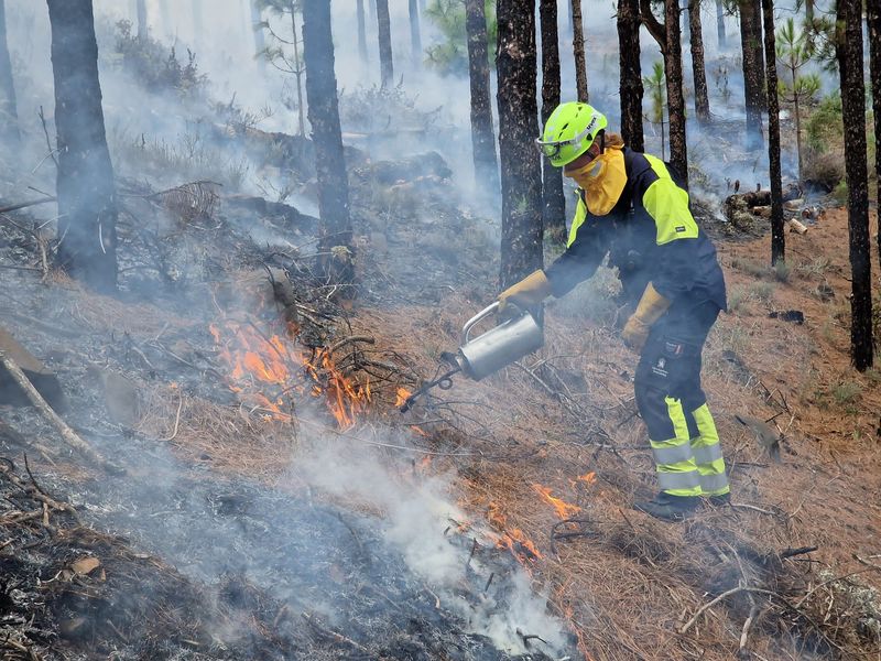
Moreover, the distinctive winter seasonality of these fires is historically linked to traditional burns aimed at maintaining grazing lands in extensive livestock systems. These burns were carried out in late winter and early spring, when livestock were stabled in the lower areas. In a period—winter to spring—and in a region—the Atlantic—where climatic conditions are generally not favourable for vegetation to ignite, certain favourable weather conditions were exploited, such as warm, dry southern winds or similar circumstances, which quickly reduce fuel moisture and make it flammable in a short time.
In Cantabria, for example, these practices were sometimes carried out even after the snow had melted, with the ground still frozen: the goal was for the wind to dry the above-ground vegetation while subsequent rains would extinguish the fire. These were low-intensity burns, conducted in small patches of forest—known as “shepherd’s burns”—or even “bush by bush,” a practice still used in Asturias.
Today, winter-spring burns are still carried out as part of traditional land management. Nevertheless, the fact that more fires are recorded than authorised burns, combined with the high proportion of intentional fires and the predominance of shrubland as the affected surface, can only be understood from the perspective of unresolved socio-territorial conflicts.
Evolution of Wildfire Risk: Threats and Future Challenges
The main threats related to wildfires in the northwest result from a combination of social and environmental factors.
Although the traditional use of fire is now regulated and requires permits, the accumulation of vegetation caused by rural abandonment over recent decades has increased fuel loads, and with them, both the risk and vulnerability to fires.
We must also consider the effects of climate change: higher temperatures and reduced rainfall create conditions more favourable for fires. The shift of winter fires into spring is a documented trend in Cantabria, where in recent years the number of fires in April and May has increased, extending a period of risk that used to be concentrated mainly in February and March.
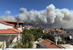
Moreover, not only is the period in which fires occur extending, but the fires are also reaching larger sizes. In 2023, Asturias experienced a wildfire that burned over 10,000 hectares and affected inhabited areas, and that same summer Galicia recorded, for the first time, simultaneous fires of 30,000 hectares. The recurrence of such large-scale fires suggests a shift in the scale of the phenomenon.
In the face of these threats, it is essential to maintain continuous and coordinated measures. This has been seen in Galicia, where the alarm caused by large wildfires led to a reduction in intentional fires since 2005, and in Asturias, where prevention and control efforts were strengthened from 2010 onward. Even so, 2025 was an exceptional year. Galicia and Castilla y León set records with fires exhibiting behaviour more typical of the Mediterranean. This new reality makes it clear that much work remains to be done. The solution is not simple: it requires a real and sustained commitment to addressing long-standing conflicts and emerging challenges.
For this reason, any strategy aimed at managing wildfire risk must promote dialogue and cooperation among all stakeholders in the territory. In this process, it is crucial to give local communities a central role, listening to their needs and recognising their key contribution to protecting and caring for the landscape. All of this must be approached in the context of the severe depopulation and abandonment affecting large rural areas of the northwest—a reality that decisively influences both prevention and response to wildfires.
Acknowledgments
We would like to thank Virginia Carracedo from the University of Cantabria and Jorge García from the Training and Operations Department of the Pau Costa Foundation for their valuable contributions and guidance. We also extend our gratitude to Víctor Riera from the Resilient Landscapes Department of the Pau Costa Foundation for his data analysis, and to Juan Picos from the University of Vigo, Javier Jiménez, a sociologist specialising in fire prevention, and Domingo Rasilla from the University of Cantabria for their reviews and input, which have helped improve this article.
Bibliography
Las Montañas de la Montaña – XXVIII Jornadas de Campo – Grupo de Geografía Física – Pasado y presente de los incendios forestales en Cantabria – Virginia Carracedo Martín. Julio 2013
Los incendios forestales en España – Decenio 2006 – 2015. Estadística General de Incendios Forestales de España (EGIF) del Ministerio para la Transición Ecológica y el Reto Demográfico (MITECO).
Tesis Doctoral – Incendios Forestales y Gestión del Fuego en Cantabria – Virginia Carracedo – 2015.